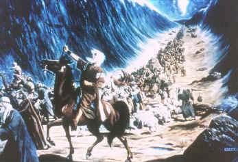
 One
of the greatest miracles wrought by God was His rescue of His "entrapped" people
by leading them through the Red Sea.
One
of the greatest miracles wrought by God was His rescue of His "entrapped" people
by leading them through the Red Sea. One
of the greatest miracles wrought by God was His rescue of His "entrapped" people
by leading them through the Red Sea.
After throwing Egypt into chaos by virtue of the 10 plagues that had been poured out on them, the Egyptians begged the Israelites to go.
The Israelites were gathered at Succoth, a common staging point for Egyptian armies prior to heading north for battle. Moses knew well the spot and gathered his people there. It was just north of the western arm of the Red Sea known today as the Gulf of Suez. There was a canal there at that time between the Mediterranean Sea and the Gulf of Suez, as well as a bridge over it.
Moses had been told by God to bring the people to Mt. Sinai in the land of Midian in Arabia, which was on the other side of what we now call the Gulf of Aqaba arm of the Red Sea (Exodus 3:12). Thus he did not take them on what was known then as the Way of the Land of the Philistines, a more direct route, but took them on a highway known as the Way of the Wilderness of the Red Sea. This highway circled down through what was called the Wilderness of the Red Sea (which we now call the Sinai peninsula) and then continues around the upper tip of the Gulf of Aqaba.
About 2/3rds of the way around this peninsula, God told Moses to lead the people off the highway and towards the Red Sea. (Exodus 14:1-3)
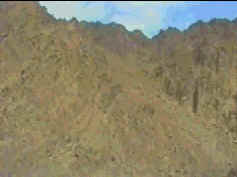
At this point, the Israelites left the Way of Wilderness of the Red Sea and entered into a canyon leading directly to the Gulf of Aqaba arm of the Red Sea.
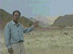
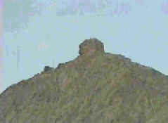
As they were still in Egyptian controlled territory, their every move was watched by military lookout posts on the surrounding hills and probably flashed via mirror relay back to Pharaoh (see photo of the ruins of such a lookout on right side below). When Pharaoh realized the Israelites were hemmed in by the mountains and the sea, he decided to pursue them (Exodus 14:3)..
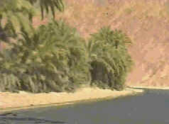
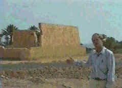
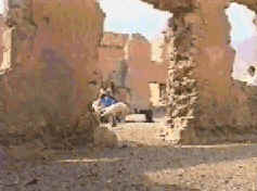
Upon arriving at the Red Sea, the Israelites found themselves on a enormous beach. This beach was 4.5 miles long by 2 miles wide (7 km x 3 km). However, (as recorded in the writings of Josephus) the mountains closed in around the beach and there was no apparent escape route. At the north end of the beach an Egyptian military garrison was stationed in a fort. You can see the fort building in the next two photos. Locals from a nearby Bedouin village still draw water from the well inside the buildings.
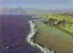
The Gulf of Aqaba is around 5,000 feet deep (1,500 m) for most of its length with a steep 45 degree slope to the bottom. However, on the side where the Israelites were trapped was the canyon they had just come through. Water rushing off the land soon after the flood had carried with it a tremendous amount of sand which had been deposited halfway out into the Gulf. Miraculously, a similar canyon had produced a tremendous deposit of sand originating from the other side. The location of both canyons was such that the sand reached each other and formed a land bridge of about 6/10ths of a mile wide (900 m) by 8 miles (13 km) long through the deep between the two sides. The slope both up and down on this land bridge was a gentle 6 degrees.
But even then, at the deepest point, the land bridge was around 1,000 feet (300 m) deep. So given that it would take around 400 psi of pressure to hold back water 1,000 feet high, how could the Israelites survive such as wind as they passed through?
Exodus 15:8 says:
"By the blast of your nostrils the waters piled up.
The surging waters stood firm like
a wall;
the deep
waters congealed in the heart of the sea."
To congeal means to turn from a liquid to a solid such as from water to ice. Moses raised his rod over the sea and God caused a strong east wind to blow, quickly freezing the water into a thick mass of ice on either side of what became a channel or trough over this land bridge.
Exodus 14:21, 22 says:
"Then Moses stretched out his hand over the sea, and all that night the Lord drove the sea back with a strong east wind and turned it into dry land. The waters were divided, and the Israelites went through the sea on dry ground, with a wall of water on their right and on their left."
Then God caused the wind to cease and the Israelites passed through on dry (and perhaps frozen?) ground.
After the Israelites reached the other side, God removed the cloud blocking the Egyptians and they pursued the Israelites, going into the trough. Moses stretched forth his rod over the sea again. The ice which was thinnest at the western side of the trough began to melt, sending water cascading into it. The water rushed into the channel and eastward carrying many of the Egyptian soldiers and their horses with it. The bodies of many of the drowned soldiers were washed up on the eastern shore at the feet of their intended victims. (Exodus 14:30)
The Bible also says that the Lord "made the wheels of their chariots come off so that they had difficulty driving" (Exodus 14:25) causing the Egyptian soldiers to become stuck. Expeditions diving along this underwater bridge discovered many coral encrusted chariots with their wheels detached. Some gold plated wheels were found indicating high level officials or priests were part of the group pursuing the Israelites. Also found were parts of skeletons of men and horses, all preserved by the coral covering them.
We hope to add some photographs here in the near future showing some of these underwater findings.
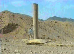
Further evidence of the underwater bridge and the crossing site comes from identical Phoenician columns found on either side of the crossing site. The inscriptions on the one found on the west side lying in the water had been eroded off. However, on the one found on the Arabian side, arachaic Hebrew inscriptions were still legible on the leeward side of the column. They read "This monument is erected by King Solomon, king of Israel, in honor of Yahweh in commemoration of the crossing of the Red Sea." King Solomon, in his building of the temple, had formed very good relations with the Phoenician people. The column on the west side was moved across the road and stood upright in concrete (see below). The column on the Arabian east side was removed and possibly moved to a museum.
The Israelites continued up the canyon and on to Mt. Sinai. And we should expect to find evidence corroborating the Bible along this route. Click here to go to the Mt. Sinai page.
The Bible proved right again! May God be glorified and our faith in Him and His word increased!
For many more photographs, video clips of what was found on the Red Sea floor, and lots more marvelous information, we recommend the video, Surprising Discoveries, Part II and the Ark of the Covenant and other Discoveries CD-ROM.
| More pictures and story |
Photos copyrighted by MindVision Interactive Pty Ltd., Adelaide, South Australia and Jonathan Gray. Used by permission.
Back to the Discoveries page - Back to Compilation List - BiblePlus Home Page